HORNTON TO HORLEY

Leave the churchyard by the east gate and go to the end of Church Lane. Turn left at the road and go up to the Methodist Church on your left. Having visited the Church, retrace your steps to The Green, now on your left, crossing this diagonally to reach the entrance to Pages Lane. Go down the lane, passing Apple Cottage on the left until after a narrow section you come to a gate. Follow the path slightly rightwards across the field (signed Footpath Horley 1 3/4) to a further gate. Go through this and head straight on across the field (signed Circular Path), ignoring options to left and right. Towards the end of the field the path curves uphill leftwards to another gate. Go through this and towards the post and wire fence ahead. Turn right on the footpath, the line of which runs somewhat below the fence and parallel to it. The path runs downhill to a gate with a pond on the right. Go through this gate and a further one and on up steps into a field. Continue with the hedgerow on your left into the next field. At he end of the field go through the gate in the corner and slightly right down to a further gate. Go through this, cross the footbridge and go up the steps and through a further gate. Go half right across the field, through a gate in the hedge and turn left up the lane. After about 70 metres turn right to a stile and , going over this, continue 1/2 left across the field to a gap in the hedge and then 1/4 right across the next field, aiming for the right end of the line of houses ahead. Follow the path down to the edge of the field and into tress. Keeping close to the hedge on your left cross a small stream and continue up to a stile in the post and wire fence. Cross this and go 1/2 left up the field. The path curves leftwards round bushes to a stile in the corner of the filed. Cross the stile and and continue along garden boundary on the left to a further stile. Cross this, go down the steps and turn left along the road. Pass Horley Manor on the right to reach St Etheldreda's Church.
HORLEY TO HANWELL
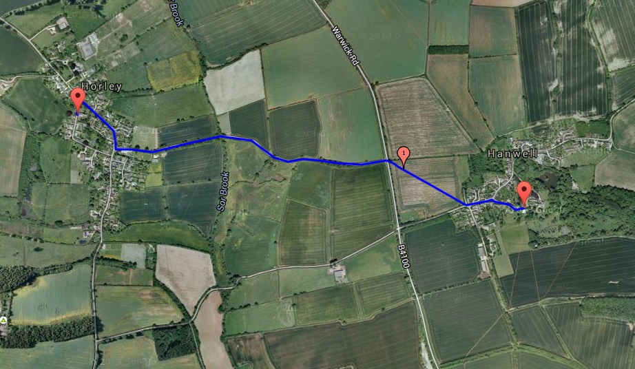
Leave the churchyard by the west gate and turn right. At the road junction cross the road and turn right down the hill. At the main road (Red Lion Pub on right) turn left (signed Banbury) and continue to the B4100 (it may feel safer to use the right-hand verge at points on this stretch). Cross the B4100, go through a gap in the hedge and turn immediately right (ignoring the option to continue straight on) into a field. Cross the field diagonally 1/2 right aiming slightly to the left of the telegraph pole on this diagonal. Go through the gap in the hedge onto the road. Bear left on the road past the Village Hall on the left to reach, after about 100 metres, Church Lane on the right (signed 12th Century Church and No Through Road). Turn down Church Lane to St Peter's Church.
HANWELL TO DRAYTON
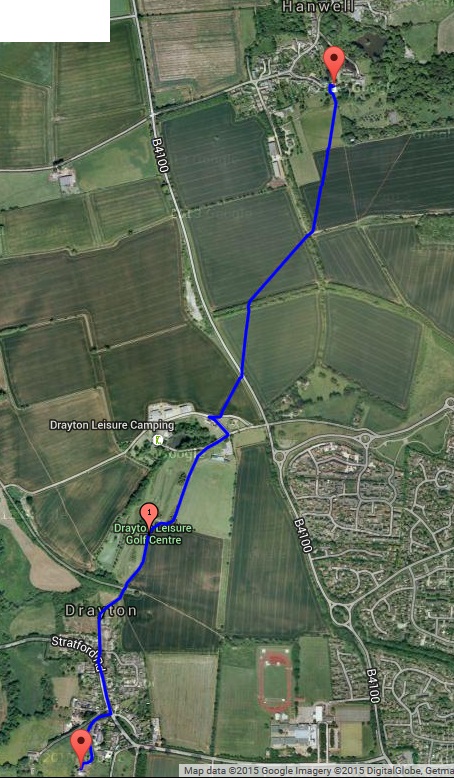
Leaving the Church by the north door turn left and left again into the churchyard. Go past the west end of the church and leave the churchyard by the south gate. Go 1/4 right (ignore the option to go straight on) across the field to a gate. Go through the gate and continue on the same line to the top right hand corner of the field. Cross the track (footpath marker) and go through the hedge. Go 1/2 right across the field to the trees at the field edge. Go through the trees and 1/4 right over the filed towards the right hand street lamp ahead of you. to reach the main road. Cross the road and turn left. Just after the 40 mph Welcome to Banbury sign turn right onto a footpath (signed Drayton 1/2). Continue 1/2 left across the field, aiming just to the right of the bungalow ahead of you (there is another house at some distance to the right of the bungalow), to reach a track. Go straight across the track and past the bungalow with its hedge on your left. At the end of the hedge cross a further a further track and turn immediately right down a track with a fence on the left and a hedge and then a fence on the right. After about 80 metres, as the tracks bears right and downwards, turn left onto another track which curves left to run between fields and then bends right. At this bend turn left into the field as continue as the track curves left following the field edge. There is a lake beneath you to the right. As you come to the bottom of a decline go slightly left with a grove of trees to your right, crossing a track to reach a gate. Pass the gate on your left and continue upwards between two fences until you come to a gate and a metalled road (Queen's Crescent). Continue straight along the road to reach the main road (Ivy Cottage on your right and Metcalfe Close on your left). Bear left up the main road, passing the Village Hall on your left, and cross the road before it curves left. Continue in the same direction until you reach the Church noticeboard and the entrance to Glebefields Care Home (footpath marker 'North Newington 1 1/2'). At Glebefields continue through the gate ahead of you (signed St Peter's Church Only) and down the hill to reach St Peter's Church.
DRAYTON TO WROXTON

Leave the church and go back up the track to the gate. Immediately after the gate turn left and then left again through a kissing gate and continue back down the hill. Turn left to a stile. Cross this and go straight across the field to a gate. Go through the gate (footpath marker) and 1/2 right across the filed to reach a wood. At the edge of the wood turn left and continue skirting the wood. At the end of the wood turn right and cross abridge over a stream. Follow the path up the hill 1/4 right towards the obelisk. At the obelisk continue 1/2 right. Cross a stile and continue 1/4 right downhill to the lake. Go on past the lake, over a stile and uphill to a gate in the corner of the field. Go through the gate and continue on the path towards a gate in the fence ahead of you. Do not go through this gate but continue on the path with the fence on your right to a further gate. Go through this and on down to emerge into Dark Lane. Turn right and with the wall of Wroxton College on your right go to the College gates and then on past them down Church Street until you reach All Saints Church at a leftward bend.
WROXTON TO BALSCOTE
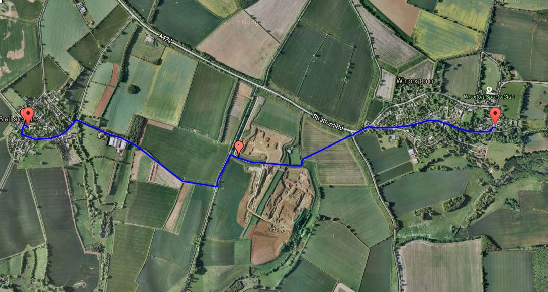
Leave the Church and go back along Church Street, passing Wroxton College gates on your left, the duckpond on your right and then the Primary School on your left until you reach the main road. Turn left and continue to the next road (signed N Newington 1 1/2). Cross the road and go past the 17th century signpost and over a stile in the hedge onto a footpath (signed). Go straight ahead across the field and at the corner of a wire fence turn left towards the quarry and then right as you reach it. Continue through quarry workings to a road (NB. The footpath may at this point be diverted because of quarrying, in which case you will need to turn right, then left along a field edge and left again to reach the road, turning right into it, having in essence walked three sides of a rectangle.) Turn left and continue for about 250 metres and then turn right down a farm track (signed footpath) on the other side of the road. Continue on the track, eventually passing barns on your left, to a road on the edge of Balscote. Turn left and follow the road up the hill round a right hand bend (do not take turn off up roads to the right) until you reach a junction with the Butchers Arms ahead of you. Turn right to reach St Mary Magdalene, Balscote on your right.
BALSCOTE TO SHENINGTON

|
On leaving St Mary Magdalene's churchyard turn right and then first left. Follow this road to the T-junction (about 800 metres) and turn right. After about 300 metres cross a stile marked 'Shenington and Alkerton' on the left of the road . Go straight on with Shenington Church ahead of you a little to the right and then go down the slope to a gate. Go through the gate and bear half left towards a track. Go leftwards along the track and follow it as it curves rightwards, keeping a line of trees on your right hand. Pass under telegraph lines to reach a stile (footpath marker: Circular Route). Go over the stile and curve right. Go through a gate and then left through another gate at a signpost directing to Shenington. Go half left down the slope and, passing a pond on your left (with a tennis court beyond), go down a stepped stone path through trees. At the end of the path turn left to reach a gate on your right. Go through this and over a stream and across a stile. Continue 1/4 right across the field to the far corner. Go into the next field and through a gate on your right (footpath marker). Go up the field 1/2 left aiming slightly to the right of a telegraph wire stanchion at the top right-hand corner. Passing the stanchion go over a stile (with a gate). Turn right down the lane and continue between houses to reach the Green. Holy Trinity Church, Shenington is to your right.
|
SHENINGTON TO ALKERTON
Turn left out of the main door of Shenington Church and leave the churchyard by the east gate to enter Chapel Lane. Turn left and cross the main road and turn right. After about 40 metres you reach a sign for the D'Arcy Dalton Way. Turn left down the path. Go through a gate and follow the path downhill to a footbridge over a stream (near a telegraph pole). Cross the footbridge via a stile and continue on to a gate. Go through the gate and then 1/2 left, aiming for the corner of a wooden fence. At the fence corner, go right along the fence and then right towards buildings and a gate. Go through the gate and between the buildings to a further gate with a stile. Cross the stile and continue to a gate on the left hand side of the drive. Go through the gate and climb the steps to the Church of St Michael and All Angels, Alkerton (left at the top of the steps).
ALKERTON TO HORNTON
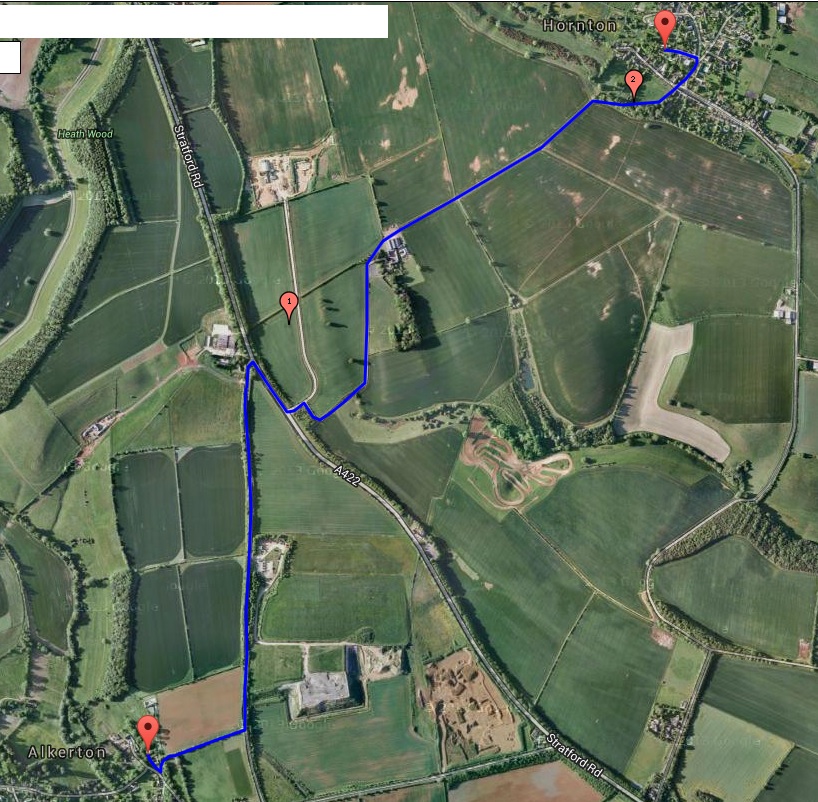
Leave Alkerton churchyard and continue past the steps by which you came up with the Old Rectory on your left. At the end of the drive turn left onto a footpath. Before Hill Barn (Access Only sign) bear right up the slope with the path curving right. Go through a gate into a field and continue along the hedgerow on your left. Go through a further gate in the field corner and continue to a stile. Cross this into the road and turn left. Continue along the road, passing the Recycling Centre, until you reach the A 422. Turn right along the verge and then cross the road to reach the entrance to Hornton Grounds Farm. Having turned left off the A422, after about 50 metres turn right at the signs for Hornton Grounds and Hornton Grounds Farm and follow the track round a left hand bend and on past the front of the farmhouse and through the farmyard to a gate (bridleway markers). Go through the gate and follow the track which eventually curves downwards and rightwards and then to the left (this hollow way is likely to be muddy) to bring you into the village of Hornton (playground on left). Go straight on past the Primary School on your left and turn left down Church Lane to reach the Church of St John the Baptist.
